The Hambleton Hills and Vale of Mowbray from Roulston Scar (Sutton Bank)
The view is to the north
The Hambleton Hills are a range of hills in North Yorkshire, England. They form the western edge of the North York Moors but are separated from the moors by the valley of the River Rye. They are the eastern boundary of the low-lying Vale of Mowbray which they abut with a precipitous escarpment.
They run in a north–south direction for about 15 miles (24 km) and merge with the Cleveland Hills in the north and Howardian Hills in the south.
The hills are made up of rocks of middle and late Jurassic age with the hard Corallian Limestone forming the cap at the highest points. The highest point is Black Hambleton which rises to 1,308 feet (400 m) at the northern end of the range. Roulston Scar reaches 919 feet (280 m) and Whitestone cliff is 1,063 feet (324 m).The Corallian Limestone also outcrops along the southern edge of the North York Moors forming the Tabular Hills which run from Black Hambleton eastwards to Scarborough, although much broken through by river valleys.
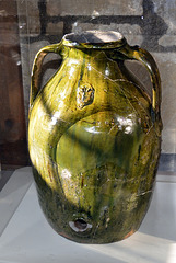
In the 12th and 13th centuries, the Hambleton Hills was the production centre for York Glazed Ware, a type of Medieval ceramic. The example below is displayed at Helmsley Castle 13 miles (20 km) to the east.
Sutton Bank (also known as Roulston Scar) is a high point on the Hambleton Hills with extensive views over the Vale of York and the Vale of Mowbray. The hill is the site of one of the most important prehistoric monuments in the region, an Iron Age hill fort built in around 400 BC.
The Hambleton Drove Road runs along the summit of the hills, it is part of an ancient highway running from Scotland to the south of England. It is thought to be prehistoric and various burial grounds from the Neolithic and Bronze Ages are evident along its route. Large-scale movement of cattle from Scotland to market in England during the 18th and 19th centuries have given it the name by which it is known today.
26 comments
Jaap van 't Veen said:
Doug Shepherd replied to Jaap van 't Veen:
All the best, Doug
Cheryl Kelly (cher12… said:
Doug Shepherd replied to Cheryl Kelly (cher12…:
All the best, Doug
©UdoSm said:
Doug Shepherd replied to ©UdoSm:
All the best, Doug
Rosalyn Hilborne said:
Have a good weekend.
Rosa.
Doug Shepherd replied to Rosalyn Hilborne:
All the best, Doug
Marie-claire Gallet said:
Doug Shepherd replied to Marie-claire Gallet:
All the best, Doug
Schussentäler said:
Doug Shepherd replied to Schussentäler:
All the best, Doug
Pam J said:
I WANNA GO HOME !!!!
BEAUTIFUL PHOTOS AND FANTASTIC GEOLOGY SCRIPT !!!
Ecobird said:
Terrific notes and PiP
Beutifully captured. Enjoy your weekend
Ulrich John said: